Monday, August 24, 2015

One Trip to Rule Them All

    At 15 or so on a lovely Maine day skipping school to go hiking, I had the basic epiphany that it was GOOD to be outside in the woods and mountains and lakes and rivers.  Not too long after that, I started to have a vague dream of canoeing down the Yukon river, with wolves and caribou running along on the wide-open tundra banks and huge arctic char practically jumping into the boat.


   At 48 I know a bit more about the nature of the Yukon river, and would probably pick somewhere else for a dream trip.
   One possible project is to land in the Aniakchak crater, run the class IV Aniakchak down to where you can carry a few miles over to the Meshik River, and then float fishily down to Bristol Bay.  Of course, then you have to somehow schlep a blowup boat several miles up the tidal flats to Port Heiden, where there's an airport, but nobody willing (apparently) to fly turistas around.  Expense and lack of services has put that plan on hold until I have some serious sabbatical time again.


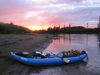
   Another idea, to go 300 or so miles down the Noatak (pictured above) has arisen, but in the end, that project seems likely to suffer from a fundamental problem: long stretches of fishing-challenged paddling (and probably against some serious wind and weather).  I'm sure the Noatak's fishing kicks the ass of just about any float I could do here in California.  But is it in the same league as the salmon-swarmed, biologically rich rivers of the Bristol Bay and Kuskokwim drainages further South?
   The Aniak River (in the Kuskokwim Kountry) presents itself as a great compromise for balancing the wild & remote with the fishy & fun.  Second-hand sources have commented that, "90% of the time I was floating down the Aniak I was scared out of my wits; but the other 10% I was having the best fishing of my life."  When I heard this a few years ago, I thought: "There."
  So, in 2013 I showed up in Aniak village with my maps and GPS and yak and all my homework done, raring to get in there are start climbing over logjams (for which the river is famous).  I quickly discerned that the pilot guy in Aniak is a little bit crazy, but, worse, I soon learned that he also a little bit cautious: because conditions were worse than usual on the main stem Aniak, he could only in good conscience drop me on the Salmon River, a relatively tame tributary of the Aniak.  Arguments ensued.  But rather than bag the whole trip, I sucked it up and started my float on the Salmon.  It turned out to be no stick in the eye, as my first-night happiness attested:


   However, it was still frustrating.  After a terrific trip full of cohos and rainbows and pike and sheefish, I beached my yak at Aniak village and radioed for my pilot to pick me up in the pickup. What does he say as soon as he sees my yak fully inflated and loaded on the beach?  "You know, I bet you could have got through the main stem in that thing."


  Fast-forward past a 2014 plan cancelled due to buying, of all things, a goddamned house, and we find your correspondent six days away from the same routine: packing up that blue yak and landing in Aniak village raring for a rare and wondrous float trip. This time I have been mildly concerned about a knee tweak in particular and my overall fitness for paddling in general, but as we get to the final prep stages, I feel READY.  Crazy Pilot informs me that the river has been as clear and friendly this year as ever.
   So it's on!  Starting next Sunday afternoon, I'll land on Aniak Lake and get ready for twelve nights on the river.  At last, I'll get to see the mouths of Atsusovluk Creek and the Kipchuk River where they empty fishily into the upper Aniak.  I'll get to climb over some logs!  Eventually, I'll get to familiar scenes at the confluence with the Salmon, and I'll fish the sublimely woggy pool there before moving on to more GPS-marked sweetspots:  "Cohomax," for a coho-a-cast slough; "Mousey" for a small tributary with a great cutbank for fishing the mouse; "Slam" where I got all main species (bow, grayling, char, coho and chum)  in one riffle, and "Slay," which I don't remember exactly, but sounds promising.  The Doestock mouth will have pike, and may produce another sheefish or two for me.  I have high and fairly realistic hopes of a seven-species fish-o-rama.


  Given my advancing age and decrepitude, will this trip be the climax of my wilderness floating career?  That's possible.  Over the past ten years, I've found that my fitness goes down for spells (plantar fascitis, gout attacks, full-time jobs intruding) and then goes up again (biking fitness, Baja trips, younger women contributing).  Hopefully on one of the ups, I'll get my sorry old ass to the Aniakchak crater, and maybe even haul a Feathercraft to the headwaters of the Noatak.  I can dream.
   But what's way more exciting than any dream, is execution.  Six days and counting down.


Sunday, April 5, 2015

Wet Year Woes

My adopted home state of California, along with everyone else West of the Mississippi, is in drought.  In fact, given the lack of rain over the past 13 years, the situation may even qualify as a megadrought.  Nice term!  Scary-sounding, and, if there's any truth in the forecast of a three-decade dry spell, genuinely scary.

And yet, my memory tells me that at least two or three of those years must have been pretty wet.  Since completing my first 210-odd miles on the John Muir trail at 19, I figure by now I must have walked at least 2000 miles in the Sierra Nevada (I'm 48) -- and quite a few of those miles were cold, snowy, wet-boot miles.

Yes, I distinctly remember an early-oughts cross-country hike over Graveyard pass, where I was surprised to see that someone else had already stuck a few walking sticks in the snow up there before their footprints got snowed over.  More recently, I've slid and stumbled and butt-glissaded in The White Stuff in places like Yosemite and Emigrant Wilderness, with witnesses!


Sometimes, lovely witnesses:


My wet tale of woe, though, was a solo late June hike in the northern Yosemite wilderness.  Experienced people will tell you, as I now know, that June is still pretty early for backpacking up high -- especially in a wet year.  But I had it in my head that I was going to be the first guy to fish a few of my favorite lakes up there at the 9,000 foot level, and I had lovely images of stripping wooly buggers in front of the noses of hungry trout along the edge of a lake still in the process of ice-out.  

Along this 20-24 mile schlep into my favorite lake, I was to experience five increasingly convincing, disturbing, and finally disastrous signs that it was not only a very wet year but -- ironically enough -- too wet for wetting a line effectively.

Sign #1

When the trail turned into a U-shaped track through meadowy areas, that track was in fact a slow-moving, inches-deep stream of clear, cold water.  To save my boots, I switched out to Tevas until my toes got numb. 

Sign #2

Arriving after about 10 miles at lovely, trouty lake at 6500 feet, I found that the lake's shore had extended WELL back into the trees.  The rocks that I had cast from in previous years were either submerged, or were little islands out in the lake, and there was a good 2-3 feet of cold-ass water lying between the pines where I might have expected to camp.  Casting a fly in those trees was not going to work well (assuming there were even any trout rooting among the pine cones), so I kept moving along.

Sign #3

The main waterway in this canyon, the same one feeding the aforementioned flooded lake, was, as I found upon climbing up the granite slopes, not the usual collection of fishable pools connected by quaint waterfalls -- it was a ROARING TORRENT.  I remember standing by the white, leaping water and having two thoughts: 
  1. "This sounds like a goddam jet engine at full blast."
  2. "This could be dangerous if I slipped and got my sorry ass swept in there."  

Sign #4

My final hope for that first day was to fish a second-favorite lake around 8,000 feet -- but that was not to be either, for a whole new Cause of Unfishability.  In this case, the flooding stream, normally crossed on stepping stones or waded at a cold but shallow ford, completely locked me away from the lake.  Believe me, I covered ground looking for a crossing of some kind.  But the prospect of wading with a backpack in four or five feet of firmly flowing, icy water didn't have great appeal.  I pitched a camp away from the stream and put all my hopes on the #1 lake, still 8-9 miles and 1000 vertical feet away.

Sign #5

If you've ever walked a hard day in the Sierras, filled with anticipation of arriving at a sweet camp and throwing your backpack down at last, you'll know exactly how I felt the following day when I rounded the last few hills blocking my view of the lake.  I was excited and walking fast through about a half-foot of damp snow. There was snow on the trees too, all of which created a fairly blinding effect in the midday Sierra sunlight, but I tramped along with my lovely image of the ice-ringed lake brimming with big, hungry trout.  Finally arriving at an overlook to the lake, what did I see?  WHITE STUFF.  A big, long field of it right where the lake should have been, without a single break of visible, liquid water surface.  The lake was still ice-covered, in late June!

Those were some wet year woes.  I got to walk through some unique conditions, and I sure got a workout -- but in one the wettest multi-day California hikes in my personal history, I did not get to wet a line.  I'm sure you appreciate that I'm not making this up, because you can't make this stuff up.

For last summer's backpacking, the bigger issues were shallow, warm water, and smoke from wildfires.  One night, after a long, hazy day, I woke up in the wee hours with genuine concern for the breathability of the air.  Smoke from various fires in the general area had created a dense, white fog around my camp.  The next day -- a much clearer day, thankfully -- my tent smelled like it had been held over a campfire. A group of kids hiking down from higher up were very relieved to hear from me that the trailhead was not actively aflame.  

I'm wondering how things will look this year.  Will the plumbed and piped lower Sacramento be running high and clear during the shad run?  Will the aqueducts in Glenn county spill the usual flood of water into the furrows between the almond trees, or into the big shallow lakes where a fat percentage of American rice is grown?  Is "megadrought" a scary enough prospect that Californians might adjust their agricultural use of water, in addition to asking citizens to wash their dishes more efficiently?  

As a guy whose wilderness activities are partly motivated by a desire to create distance from the general disappointment created by fellow humans, I'd tend to think: probably not. However, in an effort to see the glass as half full, I'll reflect that there will probably be no problem fishing a certain lake system this year, even in late June.